7. The Romans
The Romans invaded Britain in AD 43 and it took them 80 years to conquer the whole country apart from Celtic Wales (Cymru) and the Picts in Scotland. They started to leave in AD 360 and had all left by AD 410. The ruled for over 350 years.
During the early part of the Roman occupation, Shropshire lay on the western edge of the Civil Zone. It is here where they built a series of military forts. The best preserved of these is at Wall, near Cleobury Mortimer.
The Romans arrived in Shropshire, it is estimated in around AD 47 where they built Wroxeter, which they named Viroconium and which was the fourth largest Roman city in Britain. The site was originally a military base but Wroxeter became a civil town in AD78 when the Western Command was moved to Chester. Later, towards the end of the first century AD, Wroxeter became the capital of the British tribe, the Cornovii.
Although the Wroxeter site was chosen for strategic reasons it is certain that a vital factor was the presence of a very well developed Iron Age farming system close by extending along the Severn flats as far as Buildwas. Food would have been procured either by force or by the promise of protection against marauders, real or imagined. Trevor Rowley, The Shropshire Landscape
In AD 47 The Roman army attacked the Wrekin Hill Fort and there is evidence of extensive burning. The settlement was destroyed and the Cornovii leaders surrendered to Roman rule.
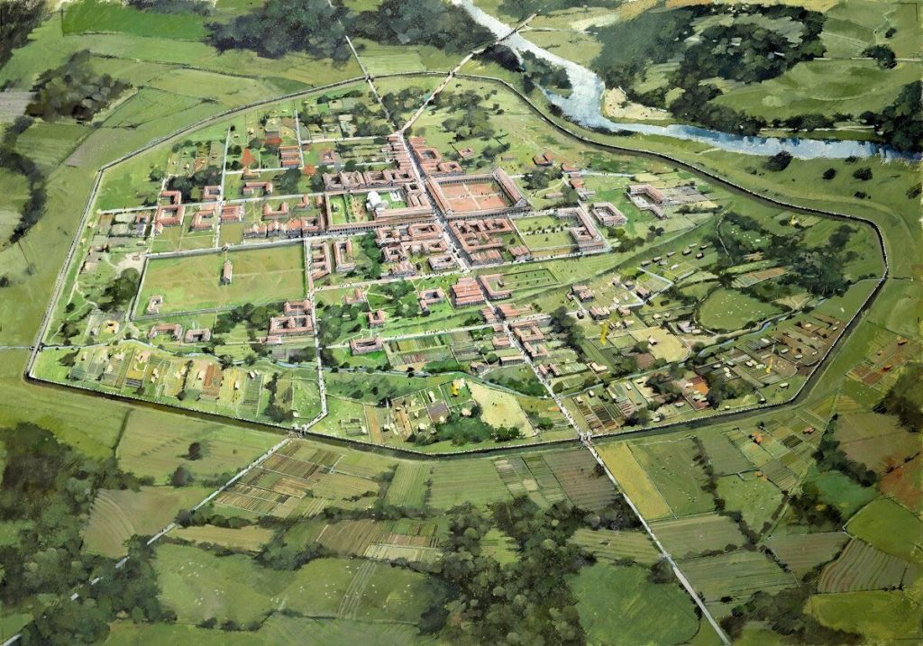
The Romans built ten villas in Shropshire, two of which have been excavated. One is at Lea Cross in Henwood, the other is Yarchester, near Harley.
This is the first evidence, albeit indirect, that there existed a farming community in the Harley area, well placed to serve the villa. A thousand years later, Domesday finally confirmed this.
Considering all the known facts as described, there seems little reason to doubt that farming, centred around the Domas area, albeit on a small scale, and maybe not continuously, existed from the late Neolithic onwards through the Bronze Age and Iron Age, on to Roman times and into the Anglo Saxon period.
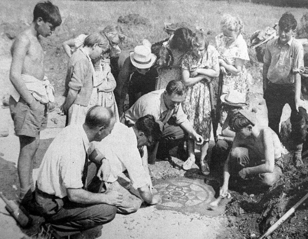
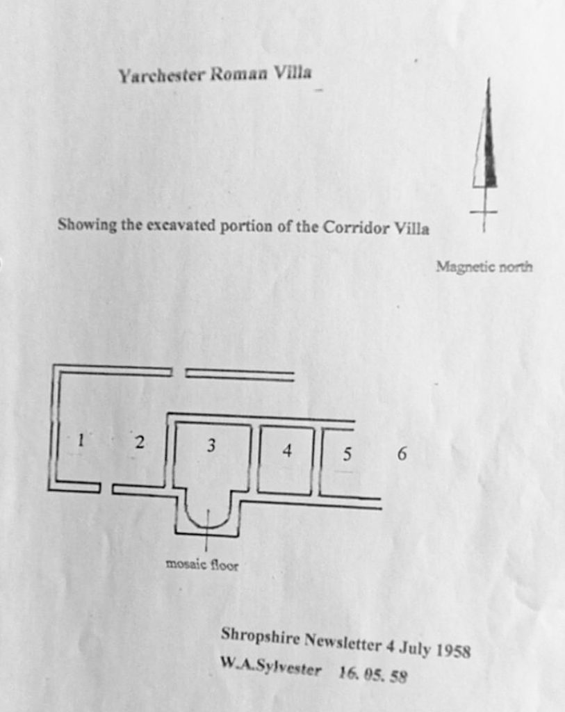
The Yarchester Villa is a Corridor Villa which was excavated in 1955 – 62 by W. A. Sylvester with help from students from the William Brookes School in Much Wenlock.
Ms A. Auden, a Shropshire Archeologist had long taken an interest in Yarchester from as early as 1925 and could have been the person who instigated the dig. Clues as the location were field names such as Hairchester and Upper Hairchester and a field near Wigwig named Airchester. Here within the previous 50 years there was said to have stood a farm building with Roman Stones in which it had been demolished prior to 1925.
When investigations started at the Yarchester field, which was being grazed by sheep, a few Roman fragments were found which had been worked to the surface by moles and it is this that seemed to have identified the site. Sadly Miss Auden died before work began in 1956 or 1957.
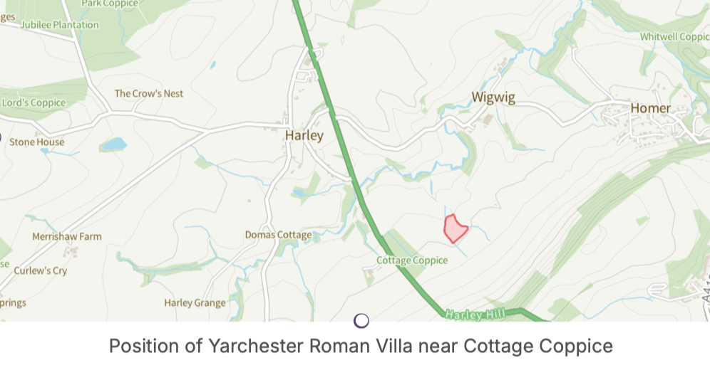
The Villa is situated on gently sloping, northwest facing ground not far from the foot of Wenlock Edge and north east of Cottage Coppice. It is also 660 metres south east of the Harley Bridge. All that is visible now is a pronounced earthwork platform.
The Villa was part of a large complex of buildings ranged around a courtyard, and it may have been fronted by a colonnade. The tiled floors were partly warmed by underfloor hypocaust heating. The buildings occupy an area of just over half an acre,
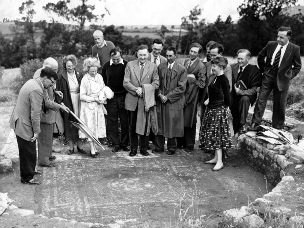
The villa itself measures 30m x 9m. There are at least five rooms, and at least two of them have mosaic floors. These are the ones which have been excavated.
In one of the rooms a complete floor slab was found. This measured 17.5 inches square. The room itself measured 17 ft. 6ins. 17.5 inches is equivalent to a Roman cubit (derived from the length of a forearm). Each slab was therefore a square cubit and the room would have been laid with 12 x 12 = 144 slabs ie.144 square cubits. A late 4th C mosaic was discovered in a room which was most likely a dining room.
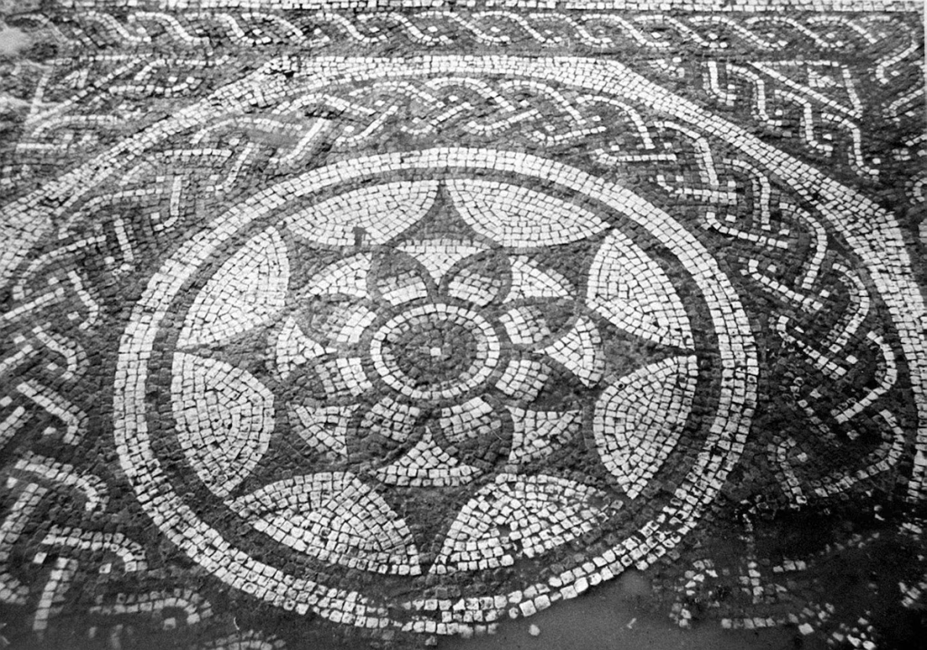
This is the central panel of the late fourth century Roman mosaic found at Yarchester Roman Villa. It is very similar to a mosaic found at Dyer Street, Cirencester and was almost certainly made by a mosaicist from that area.
The villa was occupied from around 200 AD to the mid-4th century. Typically such villas were partly or wholly stone built, many with timber framed upper sections on masonry bases. Roofs were tiled. A roof tile (Tegula) has been found during the excavations here so this villa must have had a tiled roof, at least in part. Floors were commonly tiled. Some rooms had underfloor heating. Many had heated baths,
The complex would have comprised the villa itself along with accommodation for farm workers, storage for agricultural products, all arranged around a courtyard, surrounded by paddocks, pens, yards, vegetable gardens, granaries, threshing floors, wells and hearths, all approached by tracks leading to surrounding fields.
Some Villa owners were immigrant Roman officials or entrepreneurs, but the majority were in the hands of mostly wealthy natives with a Romanised lifestyle. Life expectancy at this time was only twenty five, they may have had more longevity if they lived in the luxury of one of these villas.
Some villas were built on the site of Iron Age farmsteads. In the case of Harley with its presumed Iron Age village centred on Domas this seems unlikely.
The Roman command had guidelines as to the siting of Villas which this one does not quite satisfy. However the Villa is located on the southern bank of Harley Brook (then a river) the sun would have risen over Wenlock Edge but the Villa would have enjoyed sun on good days, from well before midday to sunset.
In those days the area would have been well treed, so forest, perhaps partly cleared would have separated the Villa from Domas.
The Villa was sited close to the long distance trackway which connected Madeley Court – a hotel in present day Telford with Ludlow Castle.
An Archaeologist excavating a courtyard at Madeley Court in 1988, which was at the time being converted into a hotel, said that his excavations in the courtyard went down to 900 AD. At that date and for long after, Madeley Court had been a Monastery and had been connected to Ludlow Castle by a footpath or trackway, also connecting with Wenlock Abbey and running along the ridge of Wenlock Edge. In Trees of Shropshire by Andrew Morton he noted that there are marker yews along sections of the track which defined the route.
The Romans were reputably better at removing trees than the natives and it may be the reason that the fields in the vicinity of the Villa are bigger than elsewhere. Small fields clustered together signifies great age for example those that occur in the Domas area next to the stream, and in the vicinity of the Water Mill.
Close to the Villa and to the north east there is a curious cropmark recorded on the Archeological Record. This shows a circular structure 25m in diameter. The record does not venture to say what this might have been. It might possibly be some use related to the Villa as there are other unexcavated structures close by. However the size and shape do not easily relate to a building. An outside chance is that it could have been a Neolithic Henge. It is the right size but the location does not closely relate to the village.
In AD 391 the Emperor Theodosius made Christianity the official state religion of the whole Roman Empire.
The early 300s were the golden age of Roman Britain. By now there was no difference between Romans and Britons. The land was peaceful and prosperous. Britain was one of the richest provinces. Hooded cloaks and saddlebags produced by the British woollen industry were famous throughout the Roman Empire. The public baths at Wroxeter would have been richly decorated and luxurious and other public buildings proclaimed the wealth of Roman Britain.
At the time, 1st to 4th century AD, it is thought there would have been a settlement with farmsteads in the Domas Area which is just off the map to the west, as this may have been the reason the Romans chose this site in the first place.
The site of the villa is positioned between two small streams emanating from issues (springs) which are marked on the above map, and which flow northwards to Harley Brook, then a river.
These two streams are shown on W.A. Sylvesters hand drawn map shown as east and west streams. The whole area would have been wooded.
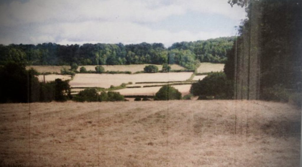
Taken from upper Domas Lane Glebe Cottage
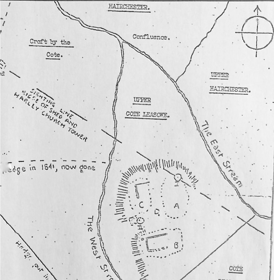
Published in the Shropshire Newsletter No.2 December 1957
Scale 1 inch to 33 yards (1/1188)
