Research
Remnant banks in the churchyard – origins of the site
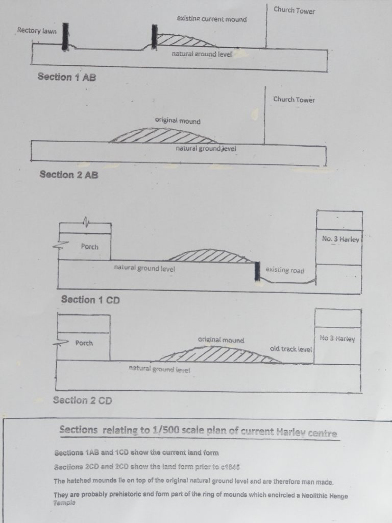
Around the church the ground levels are about 1m higher than the floor level of the church.
On the south (Porch) side there is a double sided earth bank 0.8m above the church floor level.
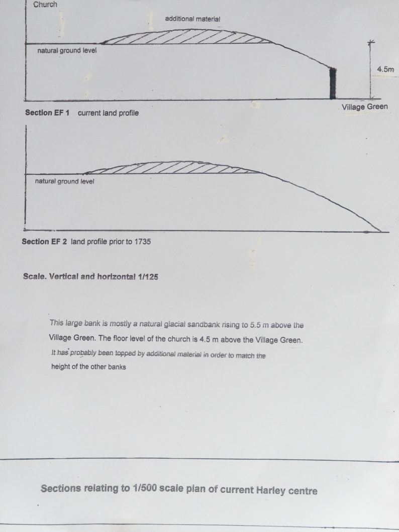
On the south east corner of the church site these banks merge with the natural 4.5m bank rising above village green.
On the west (Tower) side the level of the earth bank just inside the stone perimeter wall is 1m higher than the floor level of the church.
In both cases, the stone perimeter wall truncates the outside of the earth banks. The banks precede the retaining walls which are post 1735
On the north (Church Cottage) side, the land is generally about 1m higher than the floor level of the church. There are no banks in this area. The land may have been regraded to provide space for graves.
On the east (Chancel) side, there are no banks. There is a newer, straight, lower section of stone wall forming the church boundary and the boundary of the adjoining house Chelmarsh.
The natural original ground level in this central area of Harley is indicated by the Rectory lawn, the floor level of the church, the ground level of No 3, Harley and the Pound field. This whole area is flat.
The 1735 Map
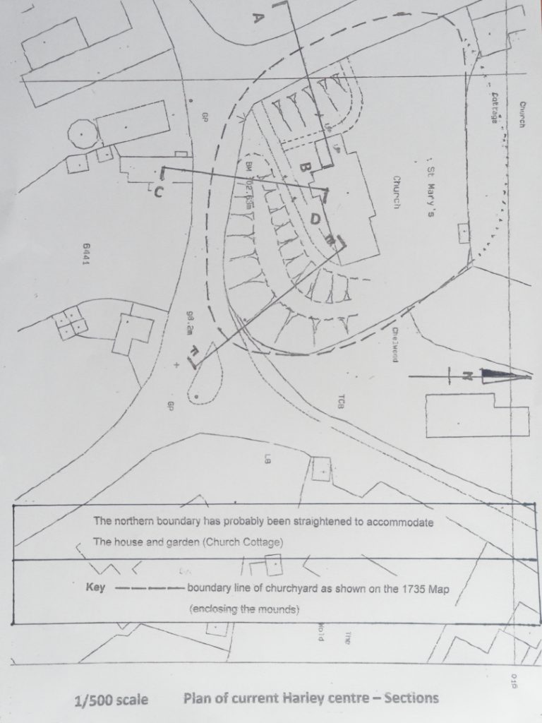
This map shows an enlarged churchyard with narrow tracks around it. It also shows, inside the boundary line, darker areas encircling the church which must represent remnant earth banks, some of which still exist on the south and west sides.
The boundary line on the Map is curved except for the northern section which is straight.
These banks, on the south and west sides, are truncated by the existing current stone perimeter retaining walls, which were obviously built post 1735, and could have been built around 1845, when the church was rebuilt under the stewardship of John Gibbons the Rector.
These banks appear to be man-made. The fact that the two remaining banks partly encircle the church indicate that there were probably other banks completing the circle.
The church site is a large sandbank located on the northern edge of the old glacier, the superficial surface deposits here being pure sand. This means that the ground shapes in the area are smooth, level or gradually sloped. Small earth banks do not occur. The wider areas, fields to the rear of Glebe Cottage, rear of No3 Harley, show this very clearly, sweeping, rolling landforms; large even drifts rather than irregular ripples or banks.
However, large earth/sand banks do occur, as can be seen in the south east corner of the church site. Here a 4.5 m bank rises up from the Village Green to the floor level of the church. This bank slowly peters out along the west side of the central Wigwig road flattening out before the bypass.
Taking into account the previous deductions regarding the question as to why the Anglo Saxons built their church on this site, the conclusion must be that the moundings formed part of the banks which encircled a prehistoric Henge Temple.
These banks must be man-made and can only be the remnants of the banks which ringed around a prehistoric temple, in the form of a timber henge. They also must have encircled the Anglo Saxon church thus supporting the theory that the Saxons chose this site because they saw that it was an ancient temple and that it was to be built in accordance with the Papal instruction of 601AD
There appears to be no other reason for their existence.
To conclude, the site is big enough to accommodate a standard small henge with banks and ditch.
The natural 4.5m high bank forming the south east corner of the site may have been an attractive feature determining the choice of the site. The constructed banks were amalgamated into the natural bank.
The existing stone boundary wall is post 1735 and was probably built in 1845 It is a retaining wall which truncates or cuts back the old mounds. It goes around 70% of the perimeter. On the west (Tower) side the Archaeologists found the old wall when doing a Field Study during the construction of the disabled access. This older wall probably circled around the northern (Church Cottage) area completing the circle of wall.
the Following Four Illustrations show:
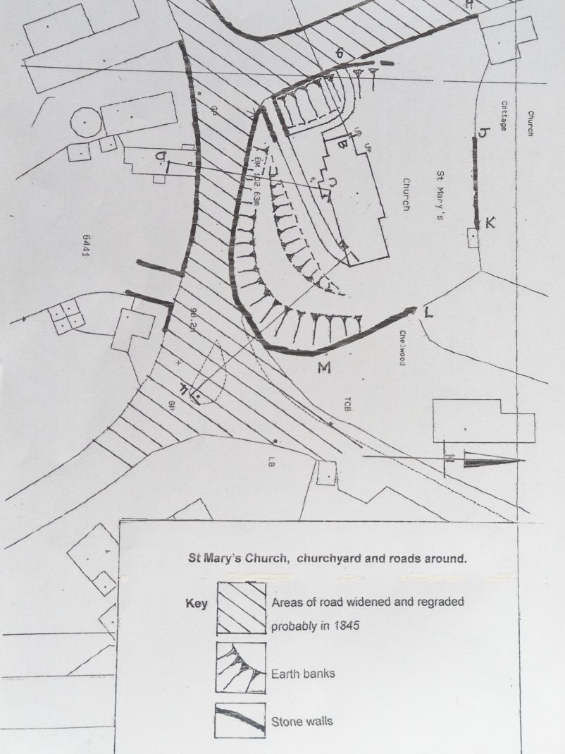
1. The extent of the roadworks around the west and south of the churchyard which probably took place around 1845 when the church was rebuilt.
2. How the stone retaining walls around the churchyard, which were necessitated by the work cut into and truncated the earth banks, thus reducing the size of the churchyard.
3. The full extent of the surrounding earth banks as shown in the 1735 map.
4. Sections through the earth banks showing why these banks on the south and west sides are almost certainly man-made, are ancient and must form part of a circle of banks surrounding the churchyard.
This strongly supports the proposition that the banks are remnants of the ring of banks and ditch along with a circle of timber posts which constitute a Neolithic Timber Henge.